At first sight, the neo-gothic edifice of Minnigaff Parish Church looks much like many others of the period. As you walk past the neat wall and railings, into the churchyard containing well-kept Victorian tomb stones, there are few clues of what lies ahead. But the deeper you probe, the more secrets this intriguing churchyard reveals.
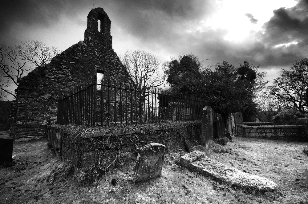
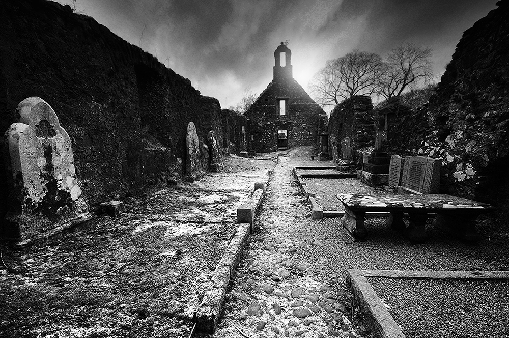
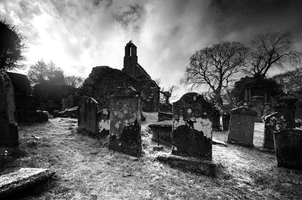
Standing on a promontory, formed between the waters of the Cree and Penkiln Burn, this sliver of land holds at least nearly 1000 years of history. Beyond the 19th century church are the ruins of a much older building, surrounded by tombstones and burial plots. At the southern tip of the churchyard, taking advantage of the natural topography, surrounded by steep banks, stands a motte, separated from the rest of the churchyard by a deep ditch, cut across its northern edge and would once have been surmounted by a wooden keep, surrounded by a palisade. It is of a type generally associated with the Anglo-Norman period and the area now covered by the churchyard may once have formed the bailey.
Andrew Symson describes the motte in 1684;
‘The village of Minygaff being situate at the foot of Polkill, in a low ground hard by the Church , there being an artificiall moat, which , by tradition , hath been handed down to posterity , as being at first contrived for sacrifising to Jupiter and the Heathen Gods ; and when Christianity obtained, it was used as a mercat – place for the inhabitants to meet and do business…’ 1
There seems here to be the tantalising suggestion of a pre-christian use for the site, a dim and distant memory of a place of pagan practice. Perhaps a prehistoric temple of some kind may have existed here before the motte and church. It’s not something beyond the realms of possibility, considering the number of prehistoric remains in the area.
Further upstream along the Cree, is a place still known as Wallace’s Camp, where local tradition tells a battle was fought nearby. R.C. Reid in his 1924/25 field trip account2, is of the opinion Wallace utilised an existing stronghold from antiquity, but the Canmore database describes the site as being caused by the extraction of gravel or sand from the old river terrace, rather than the remains of a camp. Reid continues, drawing from Blind Harry’s epic poem, ‘The Wallace’ in support of an assault on the Minnigaff motte castle by Wallace in 1297.
“A strenth thar was on the Wattir of Cre
With in a rock, rycht stalwart wrocht off tre;
A gait befor myeht no man to it wyn,
Bot the consent off thaim that duelt within.
On the bak side a rick and wattir was…”
The tale tells how Wallace and two companions, William Kerlie and Steven of Ireland, climbed the rock on which the impregnable castle stood, slew the sentry and took the castle. Blind Harry lived from 1440-92, writing some 170 years after Wallace’s death, claiming it to be based on a book by Wallace’s friend, Father John Blair. The book is unknown in modern times and it is thought his poem is more likely to be based on oral traditions. He is not considered to be a highly reliable source.
Reid surmises that the motte is the only site on the Cree which fits the description. However, Cruggleton Castle was also known as the ‘Black Rock of the Cree’. Tradition, if not history, states that Cruggleton had been held by the Kerlies for as long as could be remembered, until they were usurped by the deceitful William de Soulis in 1282, who handed the castle over to Edward I. With William Kerlie in his company, it seems far more likely Wallace would have retaken Cruggleton Castle for his friend. When Edward’s man John of Hoddleston at Wigtown Castle heard that Wallace was approaching, he fled ‘back to his own country’ leaving Wallace to take the castle and progress to Cruggleton. Although some mottes continued to be used until the 15th century, many fell out of use in favour of sturdier, stone built castles. So it may be the motte at Minnigaff had been abandoned by the time of Wallace’s campaign. Read more about Cruggleton Castle here.
The first record of the church is in 1209, when Parson Durand attested a deed. His name appears on a witness charter by John, Bishop of Galloway3. The presence of two early cross slabs also suggests at least a tenth or eleventh century origin for the church. One slab was found in 1880 within the fabric of the old church, in use as a doorstep, the other being used as a lintel in the old market house in Minnigaff at about the same time. Both were set up in a recess in the ruined church, but have now been moved inside Minnigaff Parish Church4. The crosses may suggest the church predates the motte and there is a possibly that the complex of a church and motte together, was an early lordship centre5, perhaps founded by Fergus of Galloway.
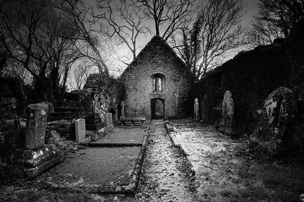
‘We next approached the two gable walls, ivy-covered, of the old parish church. It is more than half-a-century since worship was conducted in it, and it now contains several graves in the interior. But there are preserved within the walls a very fine Maltese cross, granite, erected on an ornamental pedestal, and of unknown date. It has been surmised that it was in honour of the four Evangelists, and certainly a human figure is sculptured on one of its sides. A cross of ruder form and older date was excavated out of the walls of this old church, and is now to be seen beside the other. A sculptured slab over the grave of an ecclesiastic, inserted in the church wall, has been removed.’6
There are clues in the surviving stonework, which tell us the old church has been renovated and remodelled a number of times. A medieval church would have stood here and the twin-light lancet windows in the east gable are probably the only surviving features of that building.
It seems likely that the medieval church was of the Premonstratensian order, as Tongland Abbey, founded as a Premonstratensian Abbey, later annexed Minngaff Church7. Very little is known of the church during this period, which seems to have undergone major reconstruction sometime after the reformation. The majority of the current church probably dates from the seventeenth century, with the east door certainly dating from the post-reformation period, as passing the altar during entering and leaving the building, was reserved solely for the priest8. A stone bearing the date 1706 sits in the east gable, which almost certainly attests to the date of a later remodelling.
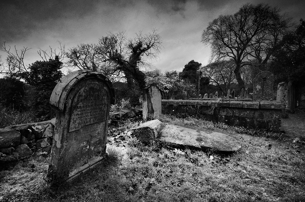
‘There are in this churchyard some very old tombstones, said to be the oldest in Galloway. We noted one, dated 1416 – A. Murray – memento mori. It also contains a considerable number of monuments of elegance and taste, and the dust of a number of Galloway’s great and good repose in its precincts.’9
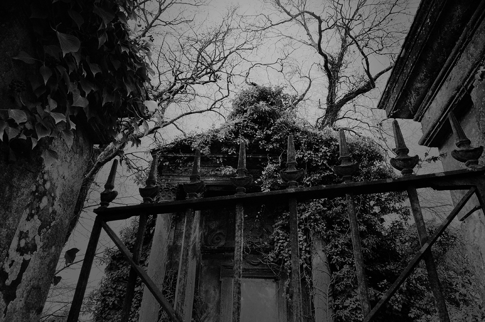
On the western edge of the cemetery stands the Heron Monument, consisting of a pediment supported by two Corinthian columns, enclosed behind balustrade walls and a heavy iron gate. It is by far the most ornate tomb in the burial ground. Built in 1761 for Patrick Heron of Kirroughtree, who’s family had gained the estate through marriage in the 15th century. His father was also called Patrick and was described as a ‘ring leader’ for the Covenanters at the Battle of Bothwell Brig in 1679. He was the MP for Kirkcudbright from 1727-41 and was instrumental in diffusing tensions during the uprising of the Galloway Levellers in 1724.
Buried with him is his son, confusingly also christened Patrick and married to Elizabeth Cochrane, a cousin of James Boswell. He too was elected as the Whig MP for Kirkcudbright in 1793, eliciting support from none other than Robert Burns, who visited Kirroughtree House and devoted a number of ballads to his election10.
But mark ye! there’s trusty Kerroughtree,
Whose honor was ever his law…
Another notable inhabitant is Sir William Stewart, about whose father, John Stewart, 7th Earl of Galloway, Burns was less complimentary. After a distinguished military career, including serving on the HMS Elephant with Nelson, throughout the battle of Copenhagen in 1801 and in the Peninsula War under Wellington, he retired to Cumloden near Minnigaff, where he died on 7th January 1827. He was also the MP for Wigtownshire on a couple of occasions. His casket style tomb lies close to the outer wall on the south eastern side of the old kirk.
Inside the church, above a recess is a heavily decorated memorial stone to Uchtred M’Dowall. The lion rampant crowned is the arms of the M’Dowalls. The three boars’ heads stand for Gordon. At the close of the 16th century two Patrick M’Kie’s of Larg married heiresses of those families. The heraldic stone is therefore 17th century and probably refers to Sir Patrick M’Kie of Larg, who ruined the family fortunes in the Covenanting period11.
There is another stone of the M’Kie family, depicting two raven, skewered by a single arrow. This refers back to a very well-known legend, dating from the Wars of Scottish Independence. During the early years of his campaign, Robert the Bruce was hiding out in the hills of Galloway from Edward’s troops. One night he came to the house of a widow at Craigencallie, who offered him food and shelter. She had three sons, all of who demonstrated their skills with a bow, the eldest son called M’Kie shot two ravens with a single arrow. All three sons joined his army, helping with the defeat of the English at the Battle of Raploch Moss in 1307. After Bannockburn, Robert awarded the widow with the lands between Palnure and Penkiln, which she divided between her sons, originating the families of M’Kie of Larg, Murdoch of Cumloden and M’Lurg of Kirroughtree12.
Emboldened by his success at Raploch Moss, Robert was eager to drive out any further scattered bands of English troops, who may lay in wait. Lord James Douglas had passed a village where 200 were stationed without posting a sentry, the Scots immediately rushed to the village and cut them to pieces. Although the name of the village isn’t given, it is the opinion of James G. Kinna that Minnigaff was the scene for the slaughter. He continues, a number of troops may have taken refuge in the church, as was the custom at the time, only for it to be set alight with them inside, “at a depth of two feet under the floor of the old Church there is a deep layer of bones covered with burnt and charred slates of a very rude description.” 13
Over 600 years of worship in the old church came to an end in 1836, when it was replaced by the current Parish Church. The old yew tree by the gate, thought to be about 900 years old, still grows on. The history this tree must have witnessed is thought provoking in the extreme. From its early days as a possible residence of the Lords of Galloway, through the centuries of catholic worship, the turbulence of the reformation and the covenanting days, through the Wars of Independence and the War of the Three Kingdoms.
Maybe it was the church that arrived here first, to Christianise a formerly pagan place of worship and the motte and lordship centre followed. If so, that would mean this had been a significant place for possibly thousands of years. And with the possibility that some of Scotland’s most heroic national figures may have passed under its shade, this tree has witnessed so much history and maybe, many secrets yet to be uncovered.

References
1. A Large Description Of Galloway – Andrew Symson 1684 (pub. 1823).
2. DGNHAS Transactions and Journal of Proceedings 1924-25 Third Series Volume 12 – R.C. Reid.
3. History of the Parish of Minnigaff – James G. Kinna (1904).
4. Canmore: canmore.org.uk/site/319607/minnigaff-old-parish-church-burial-ground-cross-slabs
5. Historic Environment Scotland: portal.historicenvironment.scot/designation/SM11054
6. DGNHAS Transactions and Journal of Proceedings 1891-92, Second Series Volume 8 – Author not given.
7. Kinna (1904)
8. Ibid.
9. Rambles in Galloway – Malcolm M’Lachlan Harper (1876).
10. Thank you to Andrew Wilson for bringing this to my attention.
11. R.C.Reid (1924-25).
12. Ibid.
13. Kinna (1904)
